Category:Oti River
Jump to navigation
Jump to search
river in West-Central Africa  | |||||
| Upload media | |||||
| Instance of | |||||
|---|---|---|---|---|---|
| Location |
| ||||
| Length |
| ||||
| Mouth of the watercourse | |||||
| Tributary |
| ||||
| Different from | |||||
 | |||||
The Oti is rising as Pendjari in the Atakora mountains in Benin and flows south of the village Damanko in Ghana in the Lake Volta. Along his course runs the border between Benin and Burkina Faso (about between the 1°52'E-meridians and the Three-Country Point Benin-Togo-Burkina Faso). On the upper course of the river in Benin is located the Pendjari National Park.
Subcategories
This category has only the following subcategory.
P
Media in category "Oti River"
The following 15 files are in this category, out of 15 total.
-
 FROBENIUS(1911) Fig21 Der Oti River oberhalb Tschopowar.jpg 696 × 517; 247 KB
-

-
 FROBENIUS(1911) Tafel38 Die Oti-Ebene bei Sansanne Mangu.jpg 656 × 472; 75 KB
-
 Canoe on Oti River.JPG 720 × 960; 352 KB
-
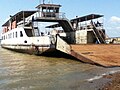 Ferry (Pontoon).JPG 960 × 720; 244 KB
-
 Ferry on Oti River.JPG 960 × 720; 259 KB
-
 Middle of Oti River.JPG 720 × 960; 123 KB
-
 Oti River.JPG 720 × 960; 258 KB
-
 Pendjari fluss (banner).JPG 2,243 × 320; 347 KB
-
 Pendjari Fluss.JPG 3,872 × 2,592; 4.42 MB
-
 Pendjari fluss.JPG 2,243 × 1,685; 1.67 MB
-
 Queen boat.JPG 720 × 960; 135 KB
-
 Rive de la rivière Pendjari.jpg 6,000 × 4,000; 2.98 MB
-
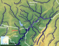 Upper Oti OMS.png 1,577 × 1,226; 2.74 MB
-
 Upper Oti.jpg 345 × 234; 37 KB
_Fig21_Der_Oti_River_oberhalb_Tschopowar.jpg)
_Fig22_Blick_auf_den_Oti_River,_f%C3%BCr_ein_Br%C3%BCckenbauvorhaben_g%C3%BCnstiger_Standort.jpg)
_Tafel38_Die_Oti-Ebene_bei_Sansanne_Mangu.jpg)

.JPG)


.JPG)